Datawave Marine Solutions
  • Dms Logo
  • Services
    • Vessel Design
      • Concept Design
    • Naval Architecture
    • Advanced Analysis
    • Marine Systems
    • Civil Engineering
  • Marine Operations
    • Passenger Vessels
    • Work Boats
    • Research Boats
    • Shipyards
    • Marine Startups
    • Waterway Maintenance
    • Autonomous Vessels
  • Portfolio
  • About Us
  • Resources
    • Blog
    • GHS Tutorials
    • FAQs
  • Contact
  • Menu Menu

How Climate Change is Impacting Seabed Mapping and Marine Dredging

The seabed beneath our ports, marinas, and coastal infrastructure isn’t as stable as it once was. Climate change is altering water levels, storm intensity, and sediment movement, which in turn is reshaping underwater terrain in ways that affect navigation and coastal operations.

Large Ship And Work Boat Going Onto Water

As these environmental shifts accelerate, industries that depend on accurate seabed mapping, reliable marine dredging, and routine marina dredging are seeing their work evolve in response.

How Climate Change Is Reshaping Coastal Seabeds

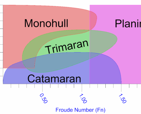
Coastal environments have always been dynamic, but climate change is increasing the pace of change. Rising sea levels, stronger storms, and altered current patterns are influencing how sediment moves along coastlines and through navigation channels.

Over time, these forces reshape the seabed by redistributing sand, silt, and other materials. Channels may gradually shoal, marina entrances can fill with sediment, and previously stable areas may begin to shift.

For marine industries, this means the underwater landscape can no longer be treated as a fixed condition. Instead, seabed conditions must be understood as part of a constantly evolving system.

This growing variability has direct implications for seabed mapping, which provides the bathymetric data needed to understand what lies beneath the surface.

Seabed Mapping Is Becoming More Frequent

Traditionally, seabed mapping surveys were performed during the planning stages of coastal projects or periodically to support dredging schedules. Today, the changing pace of seabed conditions means that many operators rely on more frequent surveys.

When storms redistribute sediment or rising sea levels alter current patterns, previously mapped seabeds can change faster than expected. New shoals may form in navigation channels, while sediment deposits can appear in marina basins or harbor approaches.

Because of these changes, seabed mapping is increasingly used to monitor how underwater terrain evolves over time rather than simply documenting conditions at a single point.

This shift reflects the growing recognition that coastal bathymetry is not static. Instead, it is shaped continuously by environmental forces that are themselves changing.

Stronger Storms and Sediment Movement

Storm intensity plays a major role in how sediment moves across the seafloor. As storm systems grow stronger or more frequent, the amount of sediment they transport can increase dramatically.

Large waves and surge events can scour material from one area and deposit it elsewhere, sometimes reshaping navigation channels or harbor basins in a single storm. These events can have immediate operational consequences:

  • Shoaling that restricts vessel access
  • Sediment buildup around docks or marina entrances
  • Changes in channel depth that affect navigation safety

Following major storms, updated seabed mapping surveys are often necessary to determine how underwater terrain has changed and whether maintenance dredging is required.

Marine Dredging in a Changing Environment

Dredging has long been used to maintain navigable waterways. However, climate-driven shifts in sediment patterns are changing how dredging projects are planned and scheduled.

In some locations, channels that historically required dredging every decade may now need maintenance more frequently due to faster sediment accumulation. In other areas, storms may deposit large volumes of material in a short period, requiring unexpected dredging work.

These conditions are affecting the broader field of marine dredging, where engineers must account for increasingly dynamic seabed conditions.

Rather than following predictable dredging cycles, many operators are adapting to more flexible schedules based on current seabed conditions and sediment movement.

The Growing Challenge of Marina Dredging

Marinas face a unique set of challenges when seabed conditions change. Because many marina basins are sheltered from strong currents, they naturally collect sediment over time.

Climate change can accelerate this process. Altered current patterns, increased runoff, and storm-driven sediment transport may cause faster buildup within marina basins or entrance channels.

For marina operators, this means that marina dredging schedules may become less predictable. Sediment may accumulate in areas that previously required little maintenance, while entrance channels may require more frequent dredging to maintain safe vessel access.

Understanding how sediment patterns evolve is becoming increasingly important for maintaining marina operations.

From developing seabed survey tools to predicting sediment deposit from storms, the team at DMS can help you control costs and create an effective plan to prepare for your next dredging project.  

Explore Marine Engineering Services

Sediment Transport Is Becoming Harder to Predict

One of the most challenging aspects of climate change is the uncertainty it introduces into coastal systems. Sediment transport depends on many interacting factors:

  • Wave energy
  • Water depth
  • Current patterns
  • Storm frequency
  • Shoreline conditions

As climate patterns shift, these variables can change simultaneously. This makes it harder to rely solely on historical data when predicting how seabeds will evolve. For industries involved in seabed mapping and marine dredging, this means that past dredging schedules and sediment models may not always reflect future conditions.

Instead, coastal operators increasingly rely on updated surveys and monitoring to track how the seabed is actually changing.

Technology Is Helping Track Seabed Changes

Modern survey technology has improved the ability to observe seabed changes in detail. Tools such as multibeam sonar and high-resolution bathymetric mapping allow engineers to create precise models of underwater terrain.

These technologies do not stop environmental changes, but they help coastal operators understand how those changes are unfolding. By comparing new seabed mapping data with historical surveys, engineers can identify patterns in sediment movement and determine where conditions are shifting most rapidly.

This information supports planning decisions related to navigation safety, dredging requirements, and coastal infrastructure maintenance.

Adapting to a Changing Coastal Environment

Climate change is not only altering weather patterns above the water: it’s reshaping the seabed below it. Ports, marinas, and coastal infrastructure must increasingly account for seabed conditions that evolve more quickly than in the past.

As a result, industries involved in seabed mapping, marine dredging, and marina dredging are adapting their practices to operate in more dynamic coastal environments. Instead of relying solely on historical conditions, many operators are monitoring seabed changes more closely and adjusting dredging plans to reflect current realities.

Understanding how these environmental forces interact with coastal infrastructure will remain a critical challenge for marine engineering in the years ahead.

Navigate the Future of Marine Infrastructure With DMS

Climate change is reshaping coastlines, sediment movement, and underwater terrain in ways that directly impact navigation channels, marinas, and coastal infrastructure. As seabed conditions evolve, industries that depend on accurate seabed mapping and effective marine dredging must adapt to a more dynamic environment.

If you’re planning a coastal project, evaluating dredging needs, or trying to better understand how seabed conditions may impact your operations, reach out to DMS. Our team can help you navigate the engineering challenges shaping the future of marine infrastructure.

Share This Post

  • Share on Facebook
  • Share on X
  • Share on WhatsApp
  • Share on Pinterest
  • Share on LinkedIn
  • Share on Tumblr
  • Share on Vk
  • Share on Reddit
  • Share by Mail

More Like This

Kitboat

5 Steps to (NOT) Build a Boat

Engineering Business, Hull Structure, Integration / Engineering, Production Engineering, Project Management, Shipyard And Support Services
https://dmsonline.us/wp-content/uploads/2020/12/KitBoat.jpg 327 436 Nate Riggins /wp-content/uploads/2025/06/DMS-logo.svg Nate Riggins2021-02-01 07:00:002026-06-01 10:09:245 Steps to (NOT) Build a Boat
M19012 Clickbait 1

Which Engineer

Design Support, Engineering Business, Hiring Consultant, Integration / Engineering, Production Engineering, Project Management, Shipyard And Support Services, Support Services
https://dmsonline.us/wp-content/uploads/2020/03/M19012_ClickBait_1.png 540 960 Nate Riggins /wp-content/uploads/2025/06/DMS-logo.svg Nate Riggins2020-03-16 07:00:362026-06-01 10:09:31Which Engineer
Hullformgraph

Video: Selecting the Right Hullform

Fluid Dynamics, Fluids, Hull Structure, Hydrostatics, Integration / Engineering, Production Engineering
https://dmsonline.us/wp-content/uploads/2018/05/HullformGraph.png 689 1195 Nate Riggins /wp-content/uploads/2025/06/DMS-logo.svg Nate Riggins2018-11-05 08:00:102026-06-01 10:09:41Video: Selecting the Right Hullform
Clickbait M18010

How Many Tons in a Pound?

Design Support, Drafting, Integration / Engineering, Production Engineering, Quality Assurance
https://dmsonline.us/wp-content/uploads/2018/10/ClickBait_M18010.jpg 720 1280 Nate Riggins /wp-content/uploads/2025/06/DMS-logo.svg Nate Riggins2018-10-22 13:00:342026-06-01 10:09:41How Many Tons in a Pound?
Previous Previous Previous Next Next Next

Categories

  • 3D Modeling
  • Arrangements
  • Auxiliary Systems
  • Command and Surveillance
  • Design Support
  • Drafting
  • Economics
  • Elastic Static Loading
  • Electrical
  • Energy Generation
  • Engineering Business
  • Equipment Integration
  • Fatigue
  • FEA / Numerical Methods
  • Fluid Dynamics
  • Fluid Loads
  • Fluids
  • Fluids Special Methods
  • Fluids Testing
  • Green Ship Design
  • Hiring Consultant
  • Hull Decks
  • Hull Structural Bulkheads
  • Hull Structure
  • Human Ergonomics
  • Hydrostatics
  • Insurance
  • Integration / Engineering
  • Legal
  • Marine Entrepreneurship
  • Masts, Kingposts, Service Platforms
  • Materials
  • Mechanical
  • Mechanical Handling Systems
  • Miscellaneous
  • Naval Architecture
  • Passenger Vessel
  • Piping
  • Production Engineering
  • Project Management
  • Propulsion
  • Propulsion Plant
  • Propulsion Units
  • Propulsor Shrouds and Ducts
  • Propulsors
  • Quality Assurance
  • Recreation
  • Regulations
  • Replenishment Systems
  • Resistance
  • Seakeeping / Fluid Structure Interaction
  • Shell and Supporting Structure
  • Ship Control Systems
  • Ship Maneuvering
  • Ship Motion Control
  • Ship Response
  • Shipyard And Support Services
  • Special Methods
  • Special Purpose Mechanical Systems
  • Special Purpose Structure
  • Stability Test
  • Structural
  • Support Services
  • Sustainable Marine Technology
  • Towing Tank
  • Transmission and Propulsor Systems
  • Unmanned Vessels
  • USCG
  • Vessel Design
  • Waterjet Propulsors

Our Socials

About Us

Ship designs tailored to your mission. Engineering that advances profits.

Dms Logo Negatives

What We Do

Vessel Design

Naval Architecture

Advanced Analysis

Marine Systems

Civil Engineering

Contact Us

(616) 504-1619

[email protected]

Website by Abstrakt Marketing Group ©
  • Privacy Policy
  • Sitemap
Scroll to top Scroll to top Scroll to top

This site uses cookies. By continuing to browse the site, you are agreeing to our use of cookies.

AcceptLearn more

Cookie and Privacy Settings


How we use cookies

We may request cookies to be set on your device. We use cookies to let us know when you visit our websites, how you interact with us, to enrich your user experience, and to customize your relationship with our website.

Click on the different category headings to find out more. You can also change some of your preferences. Note that blocking some types of cookies may impact your experience on our websites and the services we are able to offer.

Essential Website Cookies

These cookies are strictly necessary to provide you with services available through our website and to use some of its features.

Because these cookies are strictly necessary to deliver the website, refusing them will have impact how our site functions. You always can block or delete cookies by changing your browser settings and force blocking all cookies on this website. But this will always prompt you to accept/refuse cookies when revisiting our site.

We fully respect if you want to refuse cookies but to avoid asking you again and again kindly allow us to store a cookie for that. You are free to opt out any time or opt in for other cookies to get a better experience. If you refuse cookies we will remove all set cookies in our domain.

We provide you with a list of stored cookies on your computer in our domain so you can check what we stored. Due to security reasons we are not able to show or modify cookies from other domains. You can check these in your browser security settings.

Other external services

We also use different external services like Google Webfonts, Google Maps, and external Video providers. Since these providers may collect personal data like your IP address we allow you to block them here. Please be aware that this might heavily reduce the functionality and appearance of our site. Changes will take effect once you reload the page.

Google Webfont Settings:

Google Map Settings:

Google reCaptcha Settings:

Vimeo and Youtube video embeds:

Accept settingsHide notification only